
Weather & Tides
Anyone rowing on the San Francisco Bay will become very familiar with the very changeable weather and tide conditions of these waters. Fortunately, we have a number of excellent resources on line to help judge the conditions to help plan for a safe row!
While it’s important to keep an eye on the weather forecasts, we rowers must deal with the peculiar micro-climates of the bay. The general area forecasts on TV or weather sites are usually too broad (except for major winter storms). There are resources that display the readings from weather instruments in our area, which can give you a sense of conditions right now in the area you plan to row. But be alert, it can be sunny and warm at one end of Richardson Bay and foggy and windy at the other. Conditions can change by the hour. Don’t take the conditions for granted. Sausalito weather is both fascinating and, at times, very challenging.
Wind & TIDES
Two words about wind and tides: they matter. Quite a lot in fact.
While it’s important to keep an eye on the weather prediction, we rowers must deal with the peculiar micro-climates of the bay, and the general area forecasts on tv or weather sites is usually no help (except for major winter storms).
Every part of our rowing area is affected by the winds and the tides, and they change by the hour. In addition to considering “how far do I want to row?” and “where do I like to row”, you will be thinking, “what are the tides and wind doing right now?” Some areas are more effected by conditions than others, and there is almost always some good rowing water within reach, but learning to read the conditions is an important part of your open-water skills.
Always be alert! It can be sunny and warm at one end of Richardson Bay and foggy and windy at the other, and that can change by the hour. Don’t take conditions for granted. Sausalito weather is both fascinating and frustrating.
Tidal Currents
Tidal currents are very important for rowers - the speed and timing of the peak ebb and flood tides vary as you move around the bay. The NOAA has generated predictions for a number of points in our area. The sites listed below display these predictions in different ways-as graphs, daily tables and annual tables-so you can choose your favorite. But do check the predicted currents in the area you plan to row.
We’ve also linked to an iPhone app for tide predictions that some club members use. There are other apps for the iPhone, iPad and other smartphones. If you find one that you like tell us and we’ll add it to the list.
Links to currents:
Alternate source with current tables for today (Use options below table to get a graphical plot)
Suggested Apps for Wind and Tide predictions

Sailflow
SailFlow makes it easy for you to find the wind and weather data you're after no matter where you are.

Ayetides
AyeTides is an iOS app for displaying tides and currents. Available for iPhones and iPads.

Windfinder
Windfinder offers wind forecasts and weather forecasts worldwide. Also includes Animated wind maps!
Local Webcams
Sometimes the best way to determine the conditions right now is to get a look. For those of us who lack an expansive view of the bay, there are web cams that can show us a bit of it.
Sausalito Yacht Club – view of the waters off downtown Sausalito
Angel Island Cam – Ayala Cove on Angel Island
St. Francis Yacht Club – Rowing to SF? Get a preview of conditions here
Sam’s Cafe - View from Sam’s Cafe deck in Tiburon
Tides on the Bay
In San Francisco Bay the level of the two high tides and the two low tides for each day are generally not the same. In the summer the lower high and lower low tides are in the morning, so you often must avoid shallow areas. In the winter the higher high tide and higher low tide are in morning, and there is usually plenty of water.
Rowers are mainly concerned about low tides; they don’t like them because:
their oars get tangled in eelgrass in many of the shallow areas, e.g. where boats are anchored, on the East side of the channel.
they tear out the bottom of their shell by hitting rusty bolts sticking out of the bottom mud in shallow areas, e.g. near piers, the far houseboats and the Southern end of Strawberry.
they hit partially submerged rocks that they never saw before, e.g. off the Belvedere Point.
they can’t row in the far northern end of Richardson Bay.
You can still have a nice row at a low tide, you just have fewer options and you need to be more careful.

The tidal range, the difference between high and low tide, is greatest when moon and sun pull in the same or opposite direction, at new and full moons. The range is also highest in June and December when the earth’s rotation brings Sausalito closest to the plane of the moons rotation. NOAA has a comprehensive tutorial on tides. More idiosyncratic essays on topics specific to the Sausalito area can be found on this author’s website.
At the OWRC it is easy to estimate the tide level: if the gangplank to the dock is level it is a very high tide, if it angles steeply downward it is very low tide. On weekends tide information is displayed on a white board next to the gangplank. The extreme tide range for Sausalito is about -2.0 to 7.0 feet, but typically the tides range about 6 feet. Tide predictions can be obtained from the Tidelines tide prediction book on the desk of the OWRC. NOAA predictions are available on the Web.
Tidal currents
For the water level to go up and down in the Bay, water from the Pacific Ocean must come in and out through the Golden Gate; this is the tidal current at the Golden Gate. Similar currents are generated throughout the Bay. As the water level increases water flows in through the Gate, the flood; as the water level decreases water flows out of the Gate, the ebb. You might think that when the tide level was at a high or a low the current would stop, the time of slack. After all, that should be the time the current should be reversing in direction. However, there is a time lag, slack is actually about 90 minutes after a high or low.

Your "heading" and your "Track" may be different
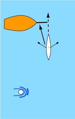
Suddenly the anchored boat is right in front!
Rowers are especially interested in tidal currents if they are rowing outside of Richardson Bay, e.g. around Angel Island. The tidal flows in the Bay create vigorous rip currents, areas of faster flow and turbulence, at points where the flow is restricted, curves around a land feature, or collides and mixes with other currents. These rips are predictable and localized phenomena; you can plan for them and avoid them if you wish, or row through if you are able, but they must be considered. The worst of them are best avoided all together, but many others create interesting small challenges on a long row.
Much of our state drains through San Francisco Bay, so in general the ebb flow is stronger than the flood; there is more water leaving than entering the bay. As the tide heights vary with the phase of the moon and the seasons, the current velocities will likewise change. Especially big tides create especially vigorous currents, and the occasional “big ebb” is a reason to be cautious.
Away from the more intense rips the general tidal flow is still a thing to consider. If you are rowing at 5 kts on an Aero up Raccoon Strait at peak ebb, you may be opposed by a current of 3 to 4 kts. Your forward progress relative to the land will be very slow, and you may labor a long while to get up Raccoon Strait. Of more concern is a current that is pushing you away from OWRC. When you head out into the open bay you must consider the currents that might help or hinder your return. Remember, “where you row is your option, but getting back is mandatory!”
Tide and Current Timing Inside the Bay
The timing and magnitude of tides and current inside the bay are not the same as the tides at the Golden Gate. Peak tides and currents occur later as you move further from the Gate. When the current is slack at the bridge there is still a quarter-hour of ebb to run in Raccoon Strait and the ebb flow at Quarry Point on Angel Island will not become slack for another 60 minutes. The NOAA publishes tide and current estimates for several points within our rowing area. As you explore the bay you will find small-scale variations in flow that are not noted in the more general NOAA tables. The complicated currents around a place like Pt. Blunt can be very surprising!
Inside Richardson
Even inside Richardson Bay it is important to be aware of currents, which can be more than 2 knts at maximum ebbs and floods. If you are rowing across a 2 knt current and want to pass in front of a boat heading into the current you need to aim 20 to 30 degrees ahead of the boat. If you aim where you want to go you will hit the boat.
You can see current as a wake made by the water as it moves past piles and buoys. Anchored boats usually swing downstream in the current. If you stop your boat completely in the water any movement (if there is no wind) must be movement of the water itself, i.e. the current.
You might also note that boats and landmarks directly astern appear to be moving to one side or the other. This again is a sign of a current.
Our rower on the right is aiming the shell well in front of the anchor chain of a boat. The boat’s heading is the dashed line, and it appears to clear the anchored boat easily.
However, the rower has ignored the wake around the buoy, the direction the anchored boat has taken in response to the current, and the lateral movement of the shell. The shell is actually moving in the direction of the solid arrow. This is the shell’s “track”, how it is actually moving in relation to the land, and to things anchored to the land.
Note the the shell is still moving very straight and true through the water, this rower’s wake appears straight behind, but the water itself is moving to the left, and carrying the rower along with it.
Now it is clear what is going to happen. The shell is going to either hit the boat or become entangled in the anchor chain. By aiming the shell instead 20 to 30 degrees up-current of the anchored boat (less in mild currents), even pointing at the stern of next anchored boat, the actual track of the shell will pass safely through the gap.
Tidal currents are stronger in the southern part of Richardson, and can be obvious amongst the anchored boats south of OWRC.